Arsenal fans, has it sunk in yet? After three consecutive second place finishes, the Gunners have ended a 22-year wait to be crowned the Premier League champions once more. The title was confirmed on Tuesday May 19, when Manchester City failed to beat Bournemouth, and Mikel Arteta’s team lifted the trophy last Sunday May 24.
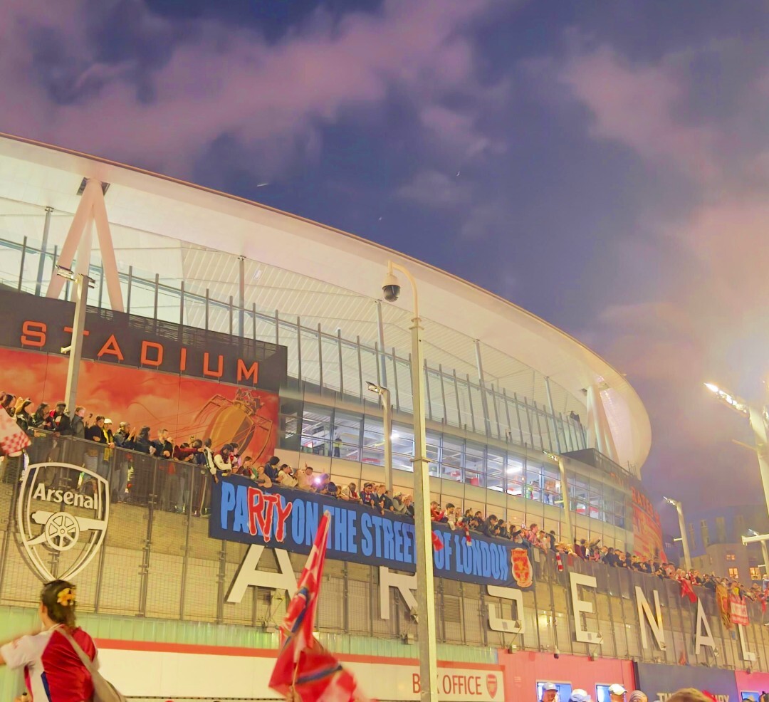
Plenty of partying has already taken place since Arsenal were confirmed as champions. Tens of thousands attended a huge unofficial party outside the Emirates overnight on the Tues-Weds, with several players joining the celebrations, with Bukayo Saka, Eberechi Eze and Declan Rice all making an appearance. More festivities took place across north London last Sunday.
A big trophy means one thing: a trophy parade. And that’s exactly what Arsenal are doing this weekend, taking over Islington (and parts of Hackney) for a triumphant open-top bus tour on Sunday May 31.
Here’s what you need to know about that parade, including its date, start time and route.
RECOMMENDED: The best Arsenal pubs to watch the Champions League final.
Arsenal trophy parade date
Mark your calendars, Gunners fans, for Sunday May 31 2026.
Start time
The parade will start at 2pm.
Route
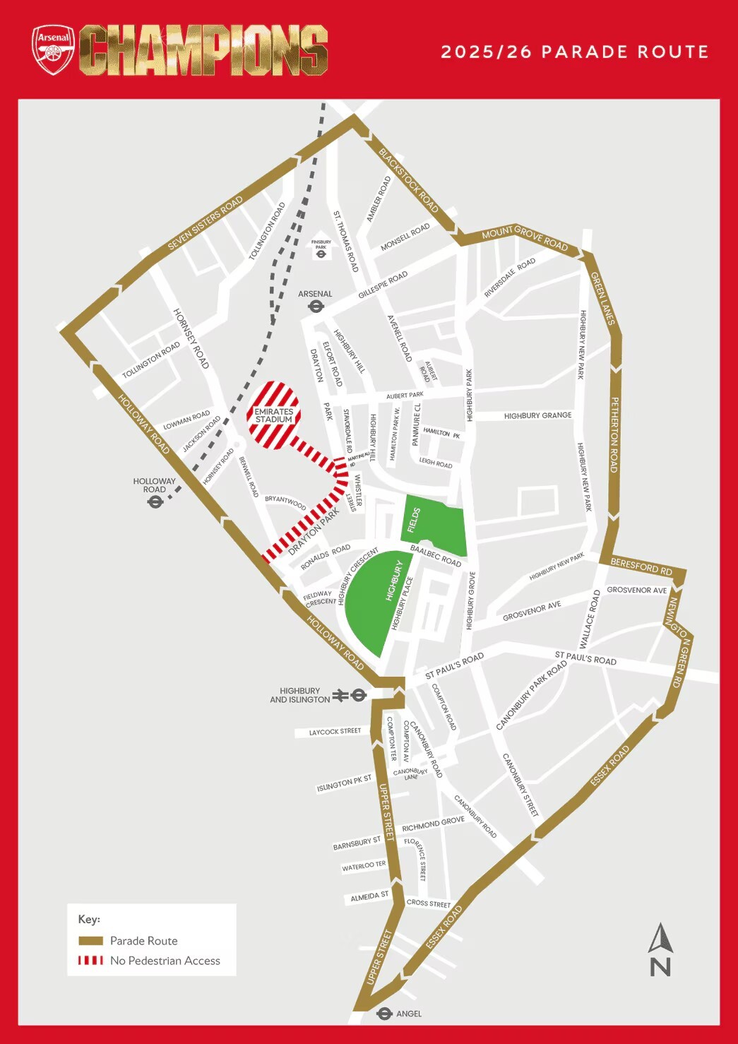
The club has confirmed the parade route. Find the map below, which shows the parade starting and ending near the Emirates Stadium, down Seven Sisters Road, Blackstock Road, Green Lanes, Essex Road, Upper Street and Holloway Road.
When did Arsenal lift the Premier League trophy?
The Gunners were awarded with the trophy last Sunday, May 24 2026. They lifted it after their final game of the season against Crystal Palace at Selhurst Park.
Road closures
From Sunday May 31 at 4am, the following roads will be closed to vehicles:
Islington
- Almeida Street
- Ambler Road, between Blackstock Road and No. 24
- Arvon Road, between Drayton Park and Witherington Road
- Ashby Grove, between Essex Road and Red House Square
- Athenaeum Court, between Petherton Road and Nos. 31–32 Orwell Court (No. 77 Petherton Road)
- Axminster Road, between Seven Sisters Road and Windsor Road
- Balls Pond Road, between Newington Green Road and Henshall Street
- Barnsbury Street, between Upper Street and College Cross
- Battishill Street
- Benwell Road, between Drayton Park and Bryantwood Road
- Beresford Road
- Beresford Terrace
- Berners Road
- Berriman Road, between Seven Sisters Road and No. 44
- Biddestone Road, between Caledonian Road and the access road for Buckmaster House, Loraine Estate
- Bingham Street
- Blackstock Road, between Seven Sisters Road and No. 164
- Bowman’s Mews
- Britannia Row, between Essex Road and Terling Walk
- Bryantwood Road
- Caledonian Road, between Camden Road and No. 570
- Camden Passage, between Upper Street and Islington High Street
- Camden Road, between Holloway Road and No. 353
- Camden Walk, between Islington Green and Camden Passage
- Canning Road, between Mountgrove Road and No. 69
- Canonbury Lane, between Upper Street and Tyndale Terrace
- Canonbury Road and the eastern arm of Highbury Corner, between Holloway Road/St. Paul’s Road/the northern arm of Highbury Corner and Compton Avenue
- Canonbury Road, between Essex Road and No. 28
- Canonbury Street, between Essex Road and Eric Fletcher Court (No. 231 Essex Road)
- Catherall Road, between Collins Road and Nos. 1–39
- Charlton Place
- Chatterton Road, between Blackstock Road and No. 5
- Chillingworth Road, between Liverpool Road and No. 6
- Church Road, between Essex Road and Red House Square
- Clephane Road, between Essex Road and No. 30
- Colebrooke Place
- Colebrooke Row, between Essex Road and Bridel Mews
- Coleridge Road, between Seven Sisters Road and No. 7
- Collins Road, between Green Lanes and Park View Estate
- Compton Terrace
- Corsica Street, between Holloway Road/St. Paul’s Road/the northern arm of Highbury Corner and No. 4 Corsica Street
- Crane Grove
- Cross Street, between Essex Road and Halton Road
- Cross Street, between Upper Street and Florence Street
- Dibden Street
- Digswell Street
- Dove Road, between Essex Road and Henshall Street
- Drayton Park, between Holloway Road and No. 68
- Durham Road, between Seven Sisters Road and Carew Close
- Eburne Road, between Seven Sisters Road and Hercules Street
- Eden Grove, between Holloway Road and Eastwood Close
- Elder Walk
- Elliott’s Place
- Elmore Street, between Essex Road and Ecclesbourne Road
- Englefield Road, between Essex Road and Crowland Terrace
- Essex Road
- Esther Anne Place
- Ferntower Road, between Petherton Road and No. 72
- Fieldway Crescent, between Holloway Road and Horsell Road
- Florence Street, the east-west arm
- Fonthill Road, between Seven Sisters Road and Biggerstaff Street
- Furlong Road
- Gaskin Street
- Georges Road, between Holloway Road and No. 15
- Gillespie Road, between Blackstock Road and Vale Row
- Goodwin Street
- Green Lanes (Arakan House entry road)
- Green Lanes, between Queen’s Drive and No. 141
- Greenman Street
- Grosvenor Avenue, between Newington Green Road and No. 57
- Halliford Street, between Essex Road and Clare Lane
- Halton Cross Street
- Halton Place
- Hercules Place
- Herrick Road, between Mountgrove Road and No. 16
- Hertslet Road, between Seven Sisters Road and Mayton Street
- Highbury Corner (A1 and A1200)
- Highbury New Park, between its northern junction with Highbury Quadrant and Nos. 273–316 Highbury New Park
- Highbury Place, between Highbury Corner and No. 3
- Highbury Quadrant (northern arm), between Green Lanes and No. 403
- Holloway Road, between Tufnell Park Road and Drayton Park
- Holloway Road, between Drayton Park and Highbury Corner
- Hornsey Road, between Holloway Road and Branston House
- Hornsey Road, between Mayton Street and the Holloway Fire Station
- Hornsey Street, between Holloway Road and Culverin Court
- Horsell Road, between Drayton Park and Witherington Road
- Isledon Road, between Seven Sisters Road and the private driveway for No. 201
- Islington Green
- Islington High Street, between Duncan Street and Islington Green
- Islington Park Street, between Upper Street and College Cross
- Jackson Road, between Holloway Road and Dunford Road
- Laycock Street
- Leconfield Road, between Petherton Road and No. 6
- Liverpool Road, between Holloway Road and No. 553
- Loraine Road, between Holloway Road and No. 9
- Madras Place, between Holloway Road and Ringcroft Street
- Marquess Road
- Medina Road, between Seven Sisters Road and Medina Grove
- Mildmay Avenue
- Mildmay Grove North, between Newington Green Road and No. 21
- Mildmay Grove South, between Newington Green Road and No. 16
- Mitchison Road, between Essex Road and No. 9
- Monsell Road, between Blackstock Road and No. 3
- Moon Street
- Morgan Road
- Mountgrove Road
- Napier Terrace
- New North Road, between Essex Road and Popham Road/Ecclesbourne Road
- Newington Barrow Way, the arm between Seven Sisters Road and Heather Close
- Newington Green Road, between Pyrland Road and St Paul’s Road
- Northampton Grove
- Northampton Park, between St Paul’s Place and No. 12
- Northampton Street, between Essex Road and The Ivories (Nos. 6–8 Northampton Street)
- Northchurch Road, between Essex Road and Crowland Terrace
- Ockendon Road, between Essex Road and No. 69
- Orleston Road
- Packington Street, between Essex Road and Cruden Street
- Palmer Place
- Parkfield Street
- Parkhurst Road, between Holloway Road and Louis Close
- Petherton Road, between Green Lanes and the Highbury Estate access road
- Pickering Street
- Playford Road
- Poet’s Road, between Petherton Road and No. 1
- Pooles Park, between Seven Sisters Road and Carville Street
- Popham Street
- Pyrland Road, between its junction with Petherton Road and No. 70
- Richmond Grove, between Upper Street and Islington Town Hall
- Rock Street
- Ronalds Road, between Holloway Road and Horsell Road
- Rotherfield Street, between Essex Road and No. 138
- Salterton Road, between Seven Sisters Road and the southern access road for Bennett Court Estate
- Seven Sisters Road, between Finsbury Park Road and Holloway Road
- Shelley Place
- Sonderburg Road
- St Paul’s Place
- St Paul’s Road, between Newington Green Road and No. 30
- St. Alban’s Place, the western and northern arms
- St. Paul’s Road, between Holloway Road/the northern arm of Highbury Corner and Keen’s Yard
- St. Peter’s Street, between Essex Road and Cruden Street
- Station Place
- Stroud Green Road, between Seven Sisters Road and Wells Terrace
- Studd Street
- Sussex Way, between Seven Sisters Road and No. 21
- Thane Villas, between Seven Sisters Road and Colonial Court
- Theberton Street, between Upper Street and the eastern arm of Gibson Square
- Tollington Road, between Holloway Road and Hertslet Road
- Tyndale Lane
- Upper Street, between Canonbury Road/the eastern arm of Highbury Corner and Duncan Street
- Wakeham Street
- Waterloo Terrace
- Whadcoat Street
- Whistler Street (western arm), between Drayton Park and No. 23
- Wicks Place
- Windsor Street
- Wyatt Road, between Mountgrove Road and No. 45
- Yonge Park, between Seven Sisters Road and No. 9
Hackney
- Blackstock Road, between Seven Sisters Road and No. 164
- Brownswood Road, between Blackstock Road and Finsbury Park Road
- Finsbury Park Road, between Mountgrove Road and No. 107
- Green Lanes (Arakan House entry road)
- Green Lanes, between Queen’s Drive and No. 141
- King’s Crescent, between Mountgrove Road and No. 29
- Mountgrove Road
- Petherton Road, between Green Lanes and the Highbury Estate access road
- Riversdale Road, between Green Lanes and No. 84
- Somerfield Road, between Blackstock Road and Finsbury Park Road
- Statham Grove, between Green Lanes and Salween House, Green Lanes
- Stoke Newington Church Street, between Green Lanes and Clissold Crescent
- Wilberforce Road, between Mountgrove Road and No. 126
Traffic filters for low traffic neighbourhoods will also be removed in the following areas:
- Canonbury East
- Canonbury West
- Highbury
- St Mary’s Church
- St Peter’s
Meanwhile, the following roads will be closed to pedestrians:
- Arvon Road, between Drayton Park and Witherington Road
- Benwell Road, between Drayton Park and Bryantwood Road
- Bryantwood Road
- Drayton Park, between Holloway Road and No. 68
- Holloway Road, the north-eastern footway, between Ronalds Road and Hornsey Road
- Horsell Road, between Drayton Park and Witherington Road
- Riversdale Road, between Green Lanes and No. 84
- Whistler Street (western arm), between Drayton Park and No. 23
Parking restrictions
Islington Council has advised that the parade route and side roads leading to it will have parking suspensions.
When is the Champions League final?
Mikel Arteta’s team could still win the double this season. They’ll face PSG in the Champions League final on Saturday May 30 2026, with kick-off at 5pm BST. If you’re lucky enough to have a ticket for the final, which is in Budapest, you’ll need to step on it to get back in time for the parade.
Get the latest and greatest from the Big Smoke – from news and reviews to events and trends. Just follow our Time Out London WhatsApp channel.
Stay in the loop: sign up for our free Time Out London newsletter for the best of the city, straight to your inbox.


